
For a downloadable PDF version of this guide CLICK HERE!
Reservoir Canyon Trail is a great half day hike for anyone in the San Luis Obispo area. The hike takes roughly three hours to complete and begins just outside of the city. From the top, you will be rewarded with incredible views of SLO, the hilly landscape that surrounds it, and the coastline.

ADVENTURE STATISTICS
Time Required:2.5 – 4 Hours
Location: Just east of San Luis Obispo
Distance: 5.3 miles (8.5km) round trip
Highest Elevation: 1700ft (520m)
Elevation Gain: 1358ft (414m)
Difficulty: 5/10 – Steep switchbacks
Season: Year Round
Additional Requirements: N/A

DRIVING DIRECTIONS
From San Luis Obispo: Jump on the 101 North for a couple miles and take a right on Reservoir Canyon Road. This road is not very well marked and T’s up with the freeway so keep your eyes peeled. A half mile down this road you will get to the parking lot and trailhead.
WHAT TO BRING
- Comfortable Footwear:Hiking shoes.Make sure your shoes are broken in prior to tackling this hike to prevent unexpected blisters. You could get away with running shoes but having extra grip on the rock surfaces will definitely come in handy!
- Water:This hike has lots of elevation gain in a short period of time. Be sure to bring enough water for 4 hours of physical exertion.
- Snacks: Bring some of your favorite snacks to enjoy along the hike. Some of our favorite snacks are trail mix, bananas, beef jerky and licorice.
- Weather appropriate clothing:You will be exposed to the elements throughout this hike. Check the weather forecast and plan accordingly.
- Sunscreen:If it is sunny and you’re like Mattson, who easily burns, bring sunscreen!
- Insect Repellent:Insect repellent can greatly improve your hiking experience.
- Camera:There are numerous photo opportunities you won’t want to miss.
- This Guide:Print a copy of this guide to reference throughout the hike
OTHER CONSIDERATIONS
Leave No Trace: It is important that we enjoy the outdoors responsibly and sustainably. Some key principles to consider when hiking to “Leave No Trace” are:
- Plan ahead and prepare: Proper planning allows adventurers to hike safely while minimizing damage to the land.
- Travel on durable surfaces: Stick to the trail when possible. If there is no trail, or you must travel off trail, stay on durable surfaces to reduce your impact.
- Dispose of waste properly: Pack it in, pack it out.
- Leave what you find: Leave rocks, plants, archaeological artifacts and other objects of interest as you find them.
- Respect wildlife: Observe wildlife from a distance. Never feed wild animals.
- Be considerate of other visitors: Be courteous to others to allow everyone to enjoy their outdoor experience.
To learn more about “Leave No Trace” visit http://www.leavenotrace.ca
HIKING DIRECTIONS
Summary: The starting point for this hike is just off of Reservoir Canyon Road. From there we recommend taking a quick detour to a small waterfall and cave before following the main trail to the summit.

Step-By-Step Guide:
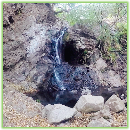
From the parking lot (Route marker #1 on the map), the trail heads south in line with the road. A short way down the trail you will come to a fork. The path to the left is reservoir canyon trail, but it’s worth your time to go right and check out a nice 30-foot waterfall and cave (Route marker #2 on the map). After checking out the waterfall, head back to the main trail to continue the hike.

The first mile of Reservoir Canyon Trail is quite level, heavily trafficked and easy to follow. The trees provide nice shade to keep you cool on a hot day. The trail follows a nearby creek and eventually crosses it via a large wooden bridge. About half a mile after crossing the bridge the trail begins to gain elevation and the challenging part of the hike begins. Over the next mile and a half, you will gain 1100 feet in elevation ascending steep switchbacks while being exposed to the hot California sun.


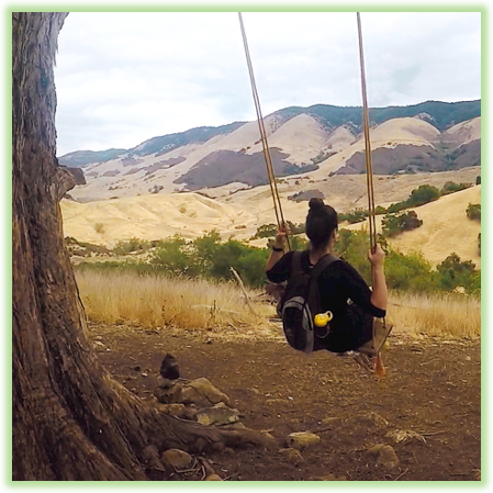
About half way up the hill, you’ll come across some scrap metal sculptures and swing that hangs from a large eucalyptus tree (Route marker #3 on the map). Enjoy a restful swing, and catch your breath before continuing on as the trail gets steeper.

At the summit you’ll find a stone memorial sculpture and a wooden bench to soak in the views (Route marker #4 on the map). San Luis Obispo surrounds the base of the hill and to the south you can see the Pismo sand dunes on the coast. Enjoy the summit views and when you feel rested and energized, follow the same trail back to the hikes starting point.

WE WANT TO HEAR FROM YOU
Thank you for choosing Epic Trip Adventures as your guide. We are committed to continually updating our guides to be as relevant and accurate as possible. If you have feedback to improve this guide please leave it in the comments below.
We also want to hear about your Reservoir Canyon adventures. If you have stories, pictures or even a link to your own adventure video please share them below!
Have fun out there!
– ETA
Comments