
For a downloadable PDF version of this guide CLICK HERE!
Bald Eagle Peak is one of the best hikes in the Canmore area. The route takes you through dense forest, up a beautiful creek bed and along a narrow ridge with a shear drop off to the valley below. The climax of the hike is an exciting scramble to the summit.

ADVENTURE STATISTICS
Time Required: 5-7 Hours
Location: Canmore, AB
Distance: 12km round trip
Highest Elevation: 2500m
Elevation Gain: 1300m
Difficulty: 8/10 – Route finding, exposure, large elevation gain and moderate scrambling.
Season: June to mid-October
Additional Requirements: N/A
DRIVING DIRECTIONS
From Canmore: Take Hwy 1 just west of Canmore to the Harvie Heights exit. Take the exit and head northwest 800m down Harvie Heights Road. Park your vehicle in the small lot on the north side of the road.
WHAT TO BRING
- Comfortable Footwear: Hiking shoes. Make sure your shoes are broken in prior to tackling this hike to prevent unexpected blisters. You could get away with running shoes but having extra grip on the rock surfaces will definitely come in handy!
- Water: This hike is long with lots of elevation gain. Be sure to bring enough water for 5-7 hours of physical exertion.
- Snacks: Bring some of your favorite snacks to enjoy along the hike as well as a light lunch for when you arrive at the summit. Some of our favorite snacks are trail mix, bananas, beef jerky and licorice.
- Weather appropriate clothing: You will be exposed to the elements throughout this hike. Check the weather forecast and plan accordingly.
- Sunscreen: If it is sunny and you’re like Mattson, who easily burns, bring sunscreen!
- Insect Repellent: Insect repellent can greatly improve your hiking experience.
- Bear Spray: You are in bear country. Always hike with bear spray that is easily accessible.
- Camera: There are numerous photo opportunities you won’t want to miss.
- This Guide: Print a copy of this guide to reference throughout the hike
OTHER CONSIDERATIONS
Wildlife: You will be hiking in bear country. It is always advisable to check in at the local Visitor Information Center to learn of any trail closures due to wildlife. Carry bear spray in an easily accessible location. Travel in groups of multiple hikers and make lots of noise to avoid an unexpected encounter.
Leave No Trace: It is important that we enjoy the outdoors responsibly and sustainably. Some key principles to consider when hiking to “Leave No Trace” are:
- Plan ahead and prepare: Proper planning allows adventurers to hike safely while minimizing damage to the land.
- Travel on durable surfaces: Stick to the trail when possible. If there is no trail, or you must travel off trail, stay on durable surfaces to reduce your impact.
- Dispose of waste properly: Pack it in, pack it out.
- Leave what you find: Leave rocks, plants, archaeological artifacts and other objects of interest as you find them.
- Respect wildlife: Observe wildlife from a distance. Never feed wild animals.
- Be considerate of other visitors: Be courteous to others to allow everyone to enjoy their outdoor experience.
To learn more about “Leave No Trace” visit http://www.leavenotrace.ca
HIKING DIRECTIONS
Summary: Bald Eagle Peak is minutes from Canmore but does not receive near as much traffic as other hikes in the area. For this reason, there is some route finding required at the beginning of this hike. Through multiple treks to this summit, we have determined the easiest and most well defined route. Starting from the parking lot (Route marker #1 on the map) off Harvie Heights Road there is a trail leading into the dense forest. From there you will travel along well-maintained paths to a drainage (Route marker #2 on the map). Follow this drainage until it becomes impassable and take the trail up the east side of the valley (Route marker #3 on the map) through the thinning trees. Once you clear the tree line follow the ridge to the protruding “bald eagle’s head” where some scrambling is required to reach the summit (Route marker #4 on the map).

Step-By-Step Guide:
From the parking lot (Route marker #1 on the map) there is a small trail heading into the forest. Follow this trail and you will come to a sign displaying the network of trails in the area.

Make your way west to the drainage (Route marker #2 on the map) indicated by the blue line on the map. Our recommended route it to follow the “Ridge Traverse” and “Tibits Quarry Trail” as indicated by the red arrow.

The drainage is large and impossible to miss. Follow the drainage northeast up the mountain.

Depending on the water levels in the drainage, it may be easy to walk right up the middle. If there is a larger volume of water flowing through the drainage keep to the right hand side as this is the direction you will ultimately go. There is some minor scrambling as you climb up the drainage over small waterfalls.
The drainage reaches a point where it is too difficult to continue travelling up but there is a small path on the right hand side (Route marker #3 on the map). Take this trail east up the side of the drainage valley.

At this point you will start to gain elevation very rapidly. The trail will take you to the east up through the trees. Once you break through the tree line the trail ends and you will be on a shale slope. Ascending up the shale is difficult and frustrating, so work your way left to the ridge.
There is a large drop to the valley below from the ridge. Follow the ridge to the summit being cautious of your footing on the lose rock. Some scrambling is required as you make your way along the ridge.
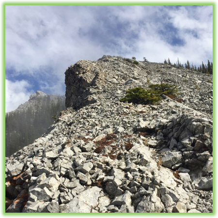
After a physically demanding climb up the ridge you will be presented with your final challenge of the hike, summiting the “bald eagle’s head”. Although it looks like the climb to the top is near impossible it is relatively moderate. Stay to the left as you approach the “eagle’s head” and ascend the slope on that side.
Continue as far around the northwest side of the “eagle’s head” as you can and there is a fairly easy trail that will lead up and to the right to the summit (Route marker #4 on the map).


Once you have reached the top, take in the incredible views of Canmore and the surrounding area. Make sure to take a brief rest and replenish on food and water as the downward trek is challenging and requires as much attention and care as the climb up. Return down the same route you ascended.
WE WANT TO HEAR FROM YOU
Thank you for choosing Epic Trip Adventures as your guide. We are committed to continually updating our guides to be as relevant and accurate as possible. If you have feedback to improve this guide please leave it in the comments below.
We also want to hear about your Bald Eagle Peak adventures. If you have stories, pictures or even a link to your own adventure video please share them below!
Have fun out there!
– ETA
Comments