
For a downloadable PDF version of this guide CLICK HERE!
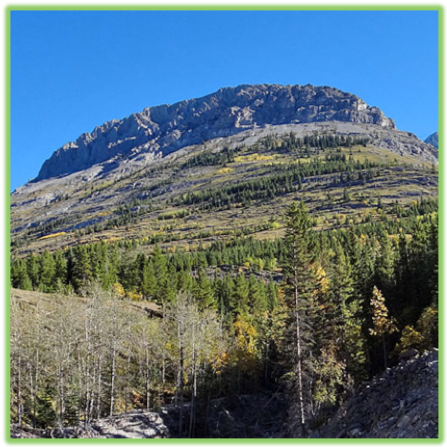
Grizzly peak is one of our favorite hikes in the Kananaskis area. Wildlife, breathtaking views the whole way up, moderate scrambling, and a lush grassy field before the summit are a few of the reasons Grizzly Peak rates so high on our list of favorites. This hike is short but steep. Fortunately, there are lots of scenic spots to stop for a breather on the way up.

ADVENTURE STATISTICS
Time Required: 4-6 Hours
Location: 78km east of Canmore in Kananaskis Country
Distance: 6.5km round trip
Highest Elevation: 2520m
Elevation Gain: 825m
Difficulty: 6/10 – Route finding, rapid elevation gain
Season: June to mid-October
Additional Requirements: N/A
DRIVING DIRECTIONS
From Calgary: Take the Trans-Canada (Hwy 1) west approximately 70 km to Kananaskis Trail (Hwy 40) and then follow that approx. 46km. The hike begins off Hwy 40 on the east side of the road. Between Km 45 and Km 46 you will pass unsigned “Ripple Creek” on your left. Pull over to the shoulder, this is where the hike begins. NOTE: There is no sign saying Ripple Creek, but Ripple Creek is located between a sign saying “Grizzly Creek” that you will pass first, and “Hood Creek”. If you see the sign saying Hood Creek, you’ve gone too far.
From Canmore: Take the Trans-Canada (Hwy 1) east approximately 30 km to Kananaskis Trail (Hwy 40) and then follow that approx. 46km. The hike begins off Hwy 40 on the east side of the road. Between Km 45 and Km 46 you will pass unsigned “Ripple Creek” on your left. Pull over to the shoulder, this is where the hike begins. NOTE: There is no sign saying Ripple Creek, but Ripple Creek is located between a sign saying “Grizzly Creek” that you will pass first, and “Hood Creek”. If you see the sign saying Hood Creek, you’ve gone too far.
WHAT TO BRING
- Comfortable Footwear: Hiking shoes. Make sure your shoes are broken in prior to tackling this hike to prevent unexpected blisters. You could get away with running shoes but having extra grip on the rock surfaces will definitely come in handy!
- Water: This hike has lots of elevation gain. Be sure to bring enough water for at least 6 hours of physical exertion.
- Snacks: Bring some of your favorite snacks to enjoy along the hike as well as a light lunch for the summit. Some of our favorite snacks are trail mix, bananas, beef jerky and licorice.
- Weather appropriate clothing: You will be exposed to the elements throughout this hike. Check the weather forecast and plan accordingly.
- Sunscreen: If it is sunny and you’re like Mattson, who easily burns, bring sunscreen!
- Insect Repellent: Insect repellent can greatly improve your hiking experience.
- Bear Spray: You are in bear country. Always hike with bear spray that is easily accessible.
- Camera: There are numerous photo opportunities you won’t want to miss.
- This Guide: Print a copy of this guide to reference throughout the hike
OTHER CONSIDERATIONS
Wildlife: You will be hiking in bear country. It is always advisable to check in at the local Visitor Information Center to learn of any trail closures due to wildlife. Carry bear spray in an easily accessible location. Travel in groups of multiple hikers and make lots of noise to avoid an unexpected encounter.
Leave No Trace: It is important that we enjoy the outdoors responsibly and sustainably. Some key principles to consider when hiking to “Leave No Trace” are:
- Plan ahead and prepare: Proper planning allows adventurers to hike safely while minimizing damage to the land.
- Travel on durable surfaces: Stick to the trail when possible. If there is no trail, or you must travel off trail, stay on durable surfaces to reduce your impact.
- Dispose of waste properly: Pack it in, pack it out.
- Leave what you find: Leave rocks, plants, archaeological artifacts and other objects of interest as you find them.
- Respect wildlife: Observe wildlife from a distance. Never feed wild animals.
- Be considerate of other visitors: Be courteous to others to allow everyone to enjoy their outdoor experience.
To learn more about “Leave No Trace” visit http://www.leavenotrace.ca
HIKING DIRECTIONS
Summary: This hike, for the most part, is fairly straight forward. The path begins on the north side of ripple creek, and wraps around to the back side of Grizzly Peak on a well-travelled trail. BUT, there are more than a few stories of hikers straying from the trail and finding themselves stuck in a gully or on a difficult scramble. If this happens, try to retrace your steps and find the trail again. In our experience, you will lose the trail more often when descending. On the way down stay high whenever possible so you don’t end up bushwhacking through the gully!

Step-By-Step Guide:
The trail begins heading up from the left (north) side of Ripple Creek (Route marker #1 on the map) with a quick ascent and a bit of a wakeup call for the legs. The first km or two are quite aggressive in elevation but about halfway up the trail levels out and travels counterclockwise around the mountain.

It can be a little difficult to follow the trail through this section. If in doubt keep sidehilling it around the mountain and stay high so that you don’t end up in the gully.


After you round the corner from this rocky area, you’ll be able to spot the saddle (Route marker #2 on the map) between the Grizzly Peak and Mount Evan-Thomas peak. Getting up to the saddle may be the most difficult part of the hike. There is a mini gully that is mostly scree that will take you to the grassy opening between the two peaks. It is a tiresome climb but that makes it even more rewarding once you get there. Some people stay way right of the scree gully and say it is a much easier ascent than going straight up the scree. Whichever way you choose, you will have to grind your way up to the saddle.


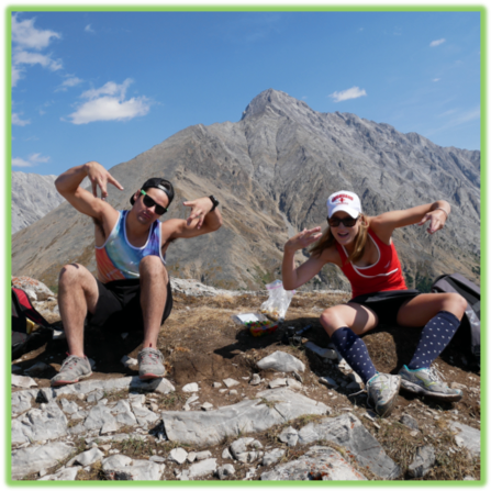
After you make it to the saddle, the summit isn’t far. Take a left so that you’re facing west, and walk up the nice gradual grassy slope. The grassy slope will quickly turn into the rocky ridge that leads to the summit of Grizzly Peak (Route marker #3 on the map)!
Remember on the way down to stay high and don’t head down into the gully. We ended up in the gully and had to bushwhack our way along Ripple Creek to the highway.

WE WANT TO HEAR FROM YOU
Thank you for choosing Epic Trip Adventures as your guide. We are committed to continually updating our guides to be as relevant and accurate as possible. If you have feedback to improve this guide please leave it in the comments below.
We also want to hear about your Grizzly Peak adventures. If you have stories, pictures or even a link to your own adventure video please share them below!
Have fun out there!
– ETA
Comments